Part 4 of the Ontario Building Code, referencing the NBCC, places clear requirements on deep excavation monitoring, particularly in urban zones. In Niagara Falls, the proximity of the Niagara River and the underlying escarpment geology make those requirements more than a formality. The overburden here is a patchwork of glacial till, lacustrine silts, and fractured shale of the Queenston Formation, often with a perched water table that fluctuates dramatically with the seasons. For projects within sight of the Horseshoe Falls, where the population sits around 94,000, the team combines seismic refraction surveys to map bedrock depth with traditional instrumentation. A typical monitoring plan along Stanley Avenue or near the tourist district has to account for vibration limits, slope deformation, and groundwater drawdown simultaneously, because disturbing one can cascade into the others.
In Niagara Falls, excavation monitoring isn't just about settlement—it's about managing the interface between glacial soils and fractured bedrock under high groundwater gradients.
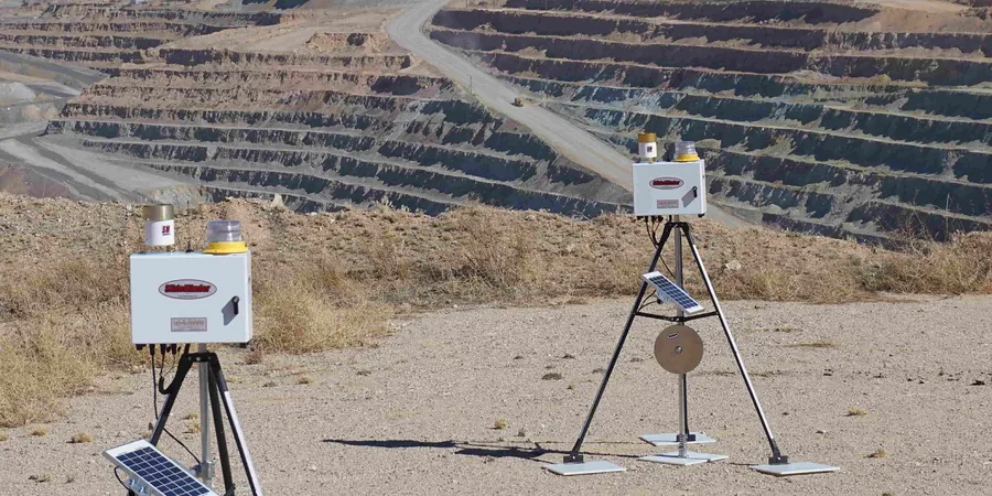
Methodology and scope
Local considerations
The Queenston Formation shale, exposed in many cut faces across the city, degrades rapidly when subjected to wet-dry cycling. We have measured up to 40 mm of relaxation displacement within 72 hours of exposing a fresh face after heavy rain. Combined with artesian pressures occasionally trapped in the overlying fractured dolostone, an unmonitored excavation can transition from stable to sloughing without warning. The 2016 Lake Erie basin flood events showed how quickly groundwater levels respond here, with piezometer readings spiking 2.8 meters in under 36 hours. A monitoring program that only checks weekly misses these transient pressures. Our instrumentation plans for the escarpment zone always include vibrating wire piezometers logged at sub-hourly intervals during the critical cut stages, plus survey prisms on adjacent structures within the zone of influence.
Applicable standards
NBCC Part 4 – Excavation and Foundation Requirements, CSA A23.3 – Design of Concrete Structures (retaining elements), ASTM D6230 – Monitoring Ground Movement Using Probe-Type Inclinometers, O. Reg. 213/91 – Construction Projects (vibration and pre-condition surveys), MTO Field Guide for Geotechnical Instrumentation and Monitoring
Associated technical services
Inclinometer and Settlement Monitoring
Installation of dual-axis in-place inclinometers and settlement plates along the perimeter of cuts, with automated data loggers that push readings to a cloud dashboard. We target the interface between surficial till and weathered shale, where differential movement concentrates.
Piezometer Networks and Dewatering Oversight
Vibrating wire and standpipe piezometers installed in nested clusters to isolate perched zones from the deeper bedrock aquifer. Real-time drawdown tracking helps adjust dewatering rates to comply with permit conditions and protect nearby wells.
Vibration and Crack Monitoring
Seismograph deployment per O. Reg. 213/91 for rock hammering or blasting, combined with optical displacement sensors and tell-tales on sensitive heritage masonry structures common in the Drummondville and Old Town neighborhoods.
Typical parameters
Frequently asked questions
What triggers the requirement for geotechnical monitoring on a Niagara Falls excavation?
Under the Ontario Building Code, any excavation deeper than 3 meters near a public right-of-way or adjacent structure typically requires a monitoring plan. In practice, the Niagara Escarpment Commission also expects instrumentation when cuts intersect the escarpment face or are within the regulated area. If the excavation encounters Queenston shale or has a dewatering component, piezometers and inclinometers become mandatory elements of the shoring design submission.
What is the typical cost range for a monitoring program on a mid-size commercial excavation in the region?
For a six-month monitoring program covering a typical commercial lot, the instrumentation supply, installation, and data reporting typically falls between CA$1,140 and CA$3,010, depending on the number of stations and whether automated readout units are required. Longer durations or projects requiring vibration monitoring on multiple heritage buildings push toward the upper end.
How is the monitoring data used during construction in real time?
Data from inclinometers and piezometers feeds into a web-based portal that the site superintendent and the geotechnical engineer access simultaneously. We set threshold alarms—for example, 25 mm of cumulative displacement or a 1-meter rise in piezometric head—that trigger notification emails. If readings approach 80% of the design limit, the team can pause excavation, review the shoring, and adjust the cut sequence before a condition becomes a non-compliance or safety issue.