A three-storey medical building proposed along Portage Road sat directly above a 12-meter cut into the Queenston Shale. The developer assumed the slope was stable because it hadn't moved in decades, but our borehole logs revealed a thin, slickensided clay seam dipping toward the excavation face at 14 degrees. That single discontinuity changed the entire foundation design. In Niagara Falls, where the Niagara Escarpment and buried gorge walls create topographic relief exceeding 40 meters within municipal boundaries, slope stability analysis is rarely about textbook homogeneous slopes. The overconsolidated Halton Till, glaciolacustrine silts, and weathered shale bedrock each introduce distinct failure mechanisms that interact in ways planar wedge analyses cannot capture. When the triaxial testing program identifies effective friction angles below 22 degrees in the basal till, we move immediately to non-circular search algorithms that trace weakness along pre-sheared horizons rather than assuming rotational slip through intact material.
A single slickensided clay seam dipping 14 degrees toward the excavation face changed the entire foundation design for that Portage Road medical building.
Methodology and scope
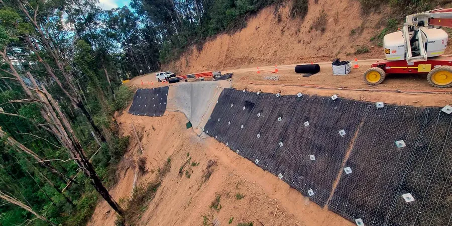
Local considerations
The contrast between two Niagara Falls neighborhoods illustrates the risk spectrum clearly. Properties in Chippawa sit on thick, normally consolidated clay plains where slope failures develop as deep-seated rotational slides with warning signs like tension cracks and toe bulging appearing months before failure. But homes along the escarpment edge near Queenston Street overlie near-vertical shale faces where block toppling can occur with essentially zero warning after freeze-thaw cycles open joint apertures beyond a critical width. We have mapped more than 60 historic landslide scarps across the city using LiDAR data from the Ontario Ministry of Natural Resources, and the pattern is unmistakable: the most damaging failures cluster where residential development encroached on slopes steeper than 25 degrees without adequate setback distances. Slope stability analysis that relies solely on aerial photo interpretation misses the subsurface complexity entirely. When we combine CPT testing through the overburden with oriented rock coring into the underlying Lockport Dolomite, we can identify the exact depth where the weathered-to-competent rock transition occurs, which is where most translational failures initiate in the escarpment environment.
Explanatory video
Applicable standards
NBCC 2020 (National Building Code of Canada) – Section 4.2, Limit States Design, Eurocode 7 (EN 1997-1:2004) – Geotechnical Design, Section 11: Overall Stability, ASTM D6467-21 – Standard Test Method for Torsional Ring Shear Test to Determine Drained Residual Shear Strength of Fine-Grained Soils, CSA A23.3-19 – Design of Concrete Structures (relevant for anchored retaining systems in slope stabilization), FHWA-NHI-05-123 – Soil Slope and Embankment Design (US Federal Highway Administration, adopted as reference for MTO projects)
Associated technical services
Residual and peak shear strength testing
Direct shear and ring shear on undisturbed samples from the failure zone to determine the critical phi-prime and cohesion intercept for both first-time slides and reactivated landslides in the Halton Till.
Multi-scenario limit equilibrium modeling
Slide2 and SLOPE/W analyses covering static, pseudo-static seismic, rapid drawdown, and construction staging conditions with non-circular search methods calibrated to local escarpment geology.
Groundwater monitoring and seepage analysis
Installation of vibrating wire piezometers and standpipe monitoring wells, coupled with SEEP/W finite element seepage models to establish pore pressure distributions for each stability scenario.
Reinforced slope design verification
Internal and external stability checks for soil nail walls, mechanically stabilized earth slopes, and anchored systems, including pullout capacity calculations using site-specific bond stress values from field pullout tests.
Typical parameters
Frequently asked questions
What Factor of Safety is required for permanent slopes in Niagara Falls under the Ontario Building Code?
Under NBCC 2020, permanent cut slopes typically require a minimum static Factor of Safety of 1.5 for long-term conditions. For temporary excavation slopes during construction, a FS of 1.3 may be acceptable where no adjacent structures are at risk. Seismic pseudo-static analyses must demonstrate a minimum FS of 1.1 using the site-specific peak ground acceleration from the NBCC seismic hazard maps, which for Niagara Region corresponds to a horizontal coefficient around 0.12.
How much does a slope stability analysis cost for a residential property on the escarpment?
A complete stability assessment for a single residential lot along the Niagara Escarpment, including site investigation, laboratory shear strength testing, and limit equilibrium analysis with a sealed engineering report, typically ranges from CA$1,530 to CA$5,150 depending on slope height, access conditions, and whether groundwater monitoring instrumentation is required. Properties with slopes exceeding 8 meters or those located within the regulated Niagara Escarpment Commission development control area tend toward the upper end of this range due to the additional cross-sections and stricter regulatory review requirements.
What is the difference between a circular and a non-circular failure surface, and when is each appropriate for Niagara Falls geology?
Circular failure surfaces assume homogeneous soil conditions and work reasonably well for deep-seated rotational slides in the thick clay plains found in Chippawa and parts of south Niagara Falls. Non-circular (block-specified or composite) surfaces become necessary where the stratigraphy includes distinct weak layers, such as the weathered shale contact at the base of the Halton Till or the pre-sheared clay seams common along the escarpment face. In these cases, the failure surface follows the path of least resistance along the weak horizon rather than cutting a mathematically smooth arc through intact material. Our standard practice for escarpment sites runs both search types and reports the most critical mechanism.