One of the most persistent errors we see on Niagara Falls projects is assuming uniform overburden thickness across a site, only to hit pinnacled limestone at 2 meters on one side of the footing and 9 meters on the other. The Lockport Dolostone and underlying Rochester Shale, shaped by post-glacial erosion and karst dissolution, create exactly this kind of irregular bedrock surface. Electrical resistivity surveys, particularly VES arrays, map these transitions without the interpolation guesswork of boreholes alone. Our field team runs Schlumberger and dipole-dipole configurations to resolve both vertical stratification and lateral anomalies before excavation begins. On sites near the Niagara Escarpment where groundwater pathways through fractured dolostone complicate dewatering plans, we combine resistivity profiling with in-situ permeability testing to cross-validate hydraulic conductivity estimates. When shallow fill over karst is suspected, a test pit program calibrated against resistivity anomalies gives the clearest picture of collapse risk.
A single VES sounding can map 60 meters of subsurface with better vertical resolution than a borehole log, at a fraction of the time and without disturbing the ground.
Methodology and scope
Local considerations
We reviewed a project on Stanley Avenue where a 6-storey mixed-use building was planned over what the preliminary geotech report called 'competent limestone at 4 meters.' Three VES soundings across the footprint revealed a low-resistivity trough dipping to 14 meters, later confirmed as a mud-filled paleochannel cut into the dolostone. Without resistivity data, the structural engineer would have designed for shallow footings on rock, and differential settlement across the channel would have cracked the slab within the first freeze-thaw cycle. Karst voids in the Lockport formation present an equally serious scenario: an air-filled cavity reads as a resistivity high, but a clay-filled sinkhole reads as a conductive low, and distinguishing between the two without electrical geophysics is practically impossible. The Ontario Building Code requires knowing what is under every load-bearing element, and resistivity provides that continuity between boreholes.
Explanatory video
Applicable standards
ASTM D6431-18 Standard Guide for Using the DC Resistivity Method, Ontario Building Code (O.Reg. 332/12) – Structural Design section, CSA A23.3-14 – Design of Concrete Structures (foundation subgrade requirements), NBCC 2015 – National Building Code of Canada (geotechnical site investigation references)
Associated technical services
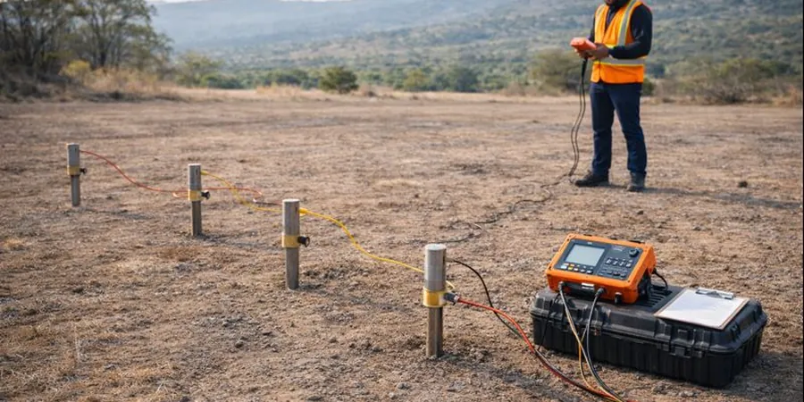
Vertical Electrical Sounding (VES) for Bedrock Profiling
Schlumberger array soundings with electrode spacings up to AB/2 = 100 m, providing 1D resistivity-depth models to map top-of-rock, karst features, and clay layer thickness. We calibrate VES curves against available borehole logs and produce true resistivity sections suitable for foundation design input.
2D Electrical Resistivity Imaging (ERI) for Lateral Anomaly Detection
Multi-electrode dipole-dipole and Wenner arrays along survey lines up to 400 m, resolving fracture zones, buried channels, and contaminant plumes. Inversion uses L1 and L2 norm optimization. We deliver iso-resistivity depth slices at 1-meter intervals for integration with CAD and BIM models.
Typical parameters
Frequently asked questions
How deep can a VES survey penetrate in the Niagara Falls area?
With a maximum current electrode spacing (AB/2) of 100 meters, a Schlumberger VES sounding typically resolves to 60–80 meters depth in competent Lockport Dolostone, and somewhat less in conductive clay overburden. Deeper penetration is achievable with longer spreads, but for most foundation and excavation projects, 60 meters comfortably covers the depth range from surface to the Rochester Shale or lower aquifer.
What is the cost of an electrical resistivity survey in Niagara Falls?
A typical VES or 2D resistivity survey in the Niagara Falls area ranges from CA$980 to CA$1,370, depending on the number of soundings, line length, electrode spacing, and terrain accessibility. Sites with heavy vegetation, steep gorge-side slopes, or asphalt surfaces requiring alternative electrode coupling may fall at the upper end of the range.
Can resistivity distinguish between air-filled and clay-filled karst cavities?
Yes, and this is one of the primary advantages of the method in karst terrain. Air-filled voids in the Lockport Dolostone produce high-resistivity anomalies, often exceeding 2,000 ohm-m, while clay-filled sinkholes or collapse features show low-resistivity signatures below 40 ohm-m. We invert the data and cross-reference with nearby borehole logs to classify the anomaly type with confidence.
How does seasonal groundwater variation affect resistivity readings?
Resistivity in the near-surface is sensitive to moisture content, and Niagara's spring melt and autumn recharge cycles can shift apparent resistivity values by 15–25% in the upper 5 meters. We account for this by scheduling surveys during representative hydrological conditions, recording soil temperature at time of acquisition, and applying saturation corrections during inversion to avoid overestimating bedrock depth during wet periods.