In Niagara Falls, the difference between a routine site investigation and one that catches a hidden shear wave reversal often comes down to how the surface array is laid out. We have seen it repeatedly across the escarpment lands, from the drumlin fields near Stamford to the lacustrine plains closer to the Whirlpool. The overburden here is deceptively variable; a stiff clay till can mask a loose silty layer at depth, and that contrast is exactly what a well-executed MASW survey picks up. Working under the NBCC 2020 framework, the VS30 value we derive is what determines whether your site falls into Site Class C, D, or E, and that classification drives the seismic design forces for everything from a single-storey commercial building to a multi-span bridge abutment. When the stratigraphy suggests trouble, we often pair the shear wave data with an SPT drilling program to calibrate the velocity profile against actual N-values and confirm refusal depths before finalizing the foundation concept.
A VS30 value alone is not the end goal; it is the site period and the velocity contrast at the soil-rock interface that really control how the ground will shake during a Lake Ontario seismic event.
Methodology and scope
Local considerations
The most common mistake we see in the Niagara Falls area is assuming that proximity to the gorge guarantees a Site Class B or C simply because bedrock is exposed at the rim. In reality, the overburden can thicken rapidly away from the escarpment edge, and a site just two blocks east of Portage Road might sit on 25 metres of soft clay that pushes it into Site Class E territory. Another frequent oversight involves using default VS30 values from regional maps without confirming the actual profile at the building location. We have reviewed projects where the designer used a Class C assumption, but the MASW data showed a velocity inversion—a stiff crust over softer material—that produced a site period close to the structural period of the proposed building, a double resonance scenario that the NBCC static force procedure does not directly capture. A site-specific ground response analysis then becomes the only defensible path forward.
Applicable standards
NBCC 2020 (National Building Code of Canada, Part 4, Division B), ASTM D4428/D4428M-14 (Standard Test Methods for Crosshole Seismic Testing), Park, C.B., Miller, R.D., and Xia, J. (1999) - Multichannel analysis of surface waves, Geophysics, CSA A23.3-19 (Design of Concrete Structures, seismic provisions)
Associated technical services
Standard VS30 Site Classification Survey
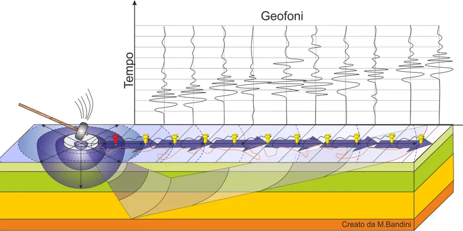
A single-array or multi-array MASW survey designed to meet NBCC Part 4 requirements for determining the average shear wave velocity in the upper 30 metres. Includes dispersion curve processing, inversion to a 1D velocity profile, and a stamped report specifying the NBCC Site Class. Suitable for commercial, institutional, and residential projects requiring a building permit in the City of Niagara Falls.
Combined MASW and Seismic Refraction Profiling
A hybrid geophysical approach for sites with complex bedrock topography, such as parcels along the escarpment slope or near buried paleochannels. The refraction data constrains the P-wave velocity and bedrock depth, while the MASW component provides the shear wave velocity structure. The combined interpretation reduces ambiguity in the inversion and improves the reliability of the VS30 calculation.
Typical parameters
Frequently asked questions
What is the typical cost of a MASW/VS30 survey in Niagara Falls?
For a standard single-array survey covering a typical commercial lot in the Niagara Falls area, the cost generally ranges from CA$2,190 to CA$4,310. The final figure depends on site access, the number of array spreads required to cover the building footprint, and whether we need to clear vegetation or work around existing structures. Multi-array surveys on larger industrial parcels or sites with steep terrain near the escarpment will fall toward the upper end of that range, and we always provide a fixed-price proposal after reviewing the site plan and aerial imagery.
How does MASW differ from a downhole seismic test?
MASW is a non-invasive surface method that measures Rayleigh wave dispersion along a linear geophone array, whereas a downhole test requires a pre-drilled borehole with a shear wave source at the surface and a clamped receiver lowered to discrete depths. MASW gives you a continuous 1D shear wave velocity profile without disturbing the soil, which is a major advantage in urban Niagara Falls where drilling access can be tight. The trade-off is that MASW resolution degrades with depth, so for very deep profiles beyond 40 metres or for sites where you need crosshole-quality measurements between boreholes, a downhole or suspension logging approach may be more appropriate.
Can you perform MASW testing during the winter months in Niagara Falls?
Yes, winter surveys are feasible and we run them regularly from December through March. Frozen ground actually improves the coupling between the geophone spike and the soil, which can yield cleaner dispersion images at high frequencies. The main constraint is heavy snow cover that prevents proper geophone planting; we schedule around fresh snowfall and clear the array line by hand when necessary. The sledgehammer source works reliably in sub-zero temperatures, and we use cold-rated cables and connectors to avoid brittleness issues.
What NBCC site class does the typical soil profile in the Fallsview area fall into?
There is no single answer for the Fallsview district because the stratigraphy changes quickly over short distances. Near the gorge rim, where the overburden is thin and the Queenston Formation shale is at or near the surface, we often measure VS30 values above 500 m/s, which places the site in Class C or occasionally Class B. Move a few blocks east toward the old Lake Iroquois basin, and the glacial lake deposits can produce VS30 values in the 200 to 300 m/s range, putting those sites squarely in Class D. We have also mapped isolated pockets of very soft silty clay near buried drainage features that fall below 180 m/s, triggering a Class E designation.
How long does a typical MASW survey take, and when do we receive the report?
A single-array survey on an open lot usually takes about two to three hours of field time, including setup, multiple hammer strikes for stacking, and teardown. Larger sites requiring three or more spreads will occupy a full day. After data acquisition, the processing and inversion work takes two to three business days in the office, and we deliver a stamped PDF report with the dispersion curves, the 1D velocity profile, and the NBCC site classification within five working days of the field visit. If you need a faster turnaround for a permit deadline, we can often accommodate a 48-hour rush on the processing side.